Showing posts with label maps. Show all posts

Wednesday, June 24, 2009

Latitude and longitude

The latitude of a place expresses how far north of the Equator it is.

  • North Pole: 90º
  • Arctic Circle: 66.56756º
  • Tropic of Cancer: 23.?º
  • Equator: 0º
  • Tropic of Capricorn: -23.?º
  • Antarctic Circle: -66.56083º
  • south pole: -90º

The longitude of a place expressed how far east of Greenwich it is. The International Date Line can be expressed as either 180º or -180º.

Edinburgh is approximately 56º latitude, -3.2º longitude. In Google Maps, this is expressed using the following URL:

http://maps.google.com/?ll=56,-3.2&z=10

Google maps basics

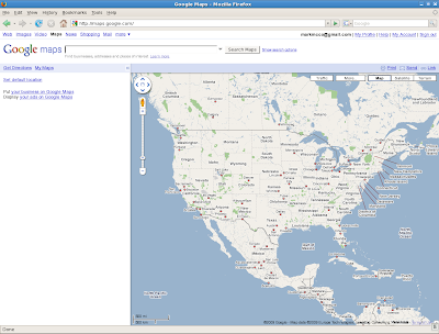
Start by going to the URL http://maps.google.com. Assuming you are signed in, you should see something like the following:

This page has three parts:

  1. the search pane, at the top
  2. the info pane, on the left
  3. the current map pane, on the right

The info pane can be minimised, in order to increase the size of the current map pane.

Things you can do with the current map pane:

  1. Click on one of the arrow icons at the top left to scroll north, south, east or west to a new map. If you click on the hand icon in the centre, you will be taken back to the original map.
  2. Click and hold the mouse button - the pointer change from a hand to a clenched fist, which you can drag around to scroll in any direction you want to a new map.
  3. Click on the plus or minus icons on the left in order to zoom in or out to a new map. You can also drag the bar between the two icons to zoom faster.
  4. Double click the mouse button to centre the map on a new point AND zoom in one level, thus giving a new map.
  5. Use the hyperlinks at the top right of the map pane to switch between map, satellite (with or without place names) and terrain view of the current map.

Other things you can do:

  1. Reset your default map, using the relevant link in the info pane.
  2. See the URL of the current map, using the 'link' link at the top right of the current map pane.
  3. Email that URL to someone, using the 'send' link.
  4. Right click, 'what's here?'

Google mapplet basics

From this page here.

A mapplet is an XML file on your own webserver, which overlays stuff on the standard Google maps page. You run the mapplet in your webbrowser as follows:

http://maps.google.com/ig/add?synd=mpl&pid=mpl&moduleurl=...

For example, here is mine.

Here is the code for my mapplet:

<?xml version="1.0" encoding="UTF-8"?>
<Module>
  <ModulePrefs title="Bum bum bum" 
               description="Says bum a lot"
               author="Mark McConville"
               author_email="markmcco@gmail.com"
               height="150">
    <!-- load the Google mapplets API -->
    <Require feature="sharedmap"/>    
  </ModulePrefs>
  <Content type="html"><![CDATA[
    <!-- Add a title to the left-hand info pane -->
    <h2>Bum bum bum!</h2>
    <!-- Manipulate the map pane -->
    <script>
      <!-- create a new map -->
      var map = new GMap2();
      <!-- centre the map in middle of Mediterranean and zoom out to level 2 -->
      var point = new GLatLng(37.71859,6.679688);
      map.setCenter(point,2);
      <!-- add a marker/pin to the point -->
      var marker = new GMarker(point);
      map.addOverlay(marker);
      <!-- add an info bubble to the marker -->
      marker.openInfoWindowHtml("Bum bum bum!");
    </script>
    ]]>
  </Content>
</Module>